
- Overview
- Trip Outline
- Trip Includes
- Trip Excludes
- Gallery
- Reviews
- Booking
- FAQ
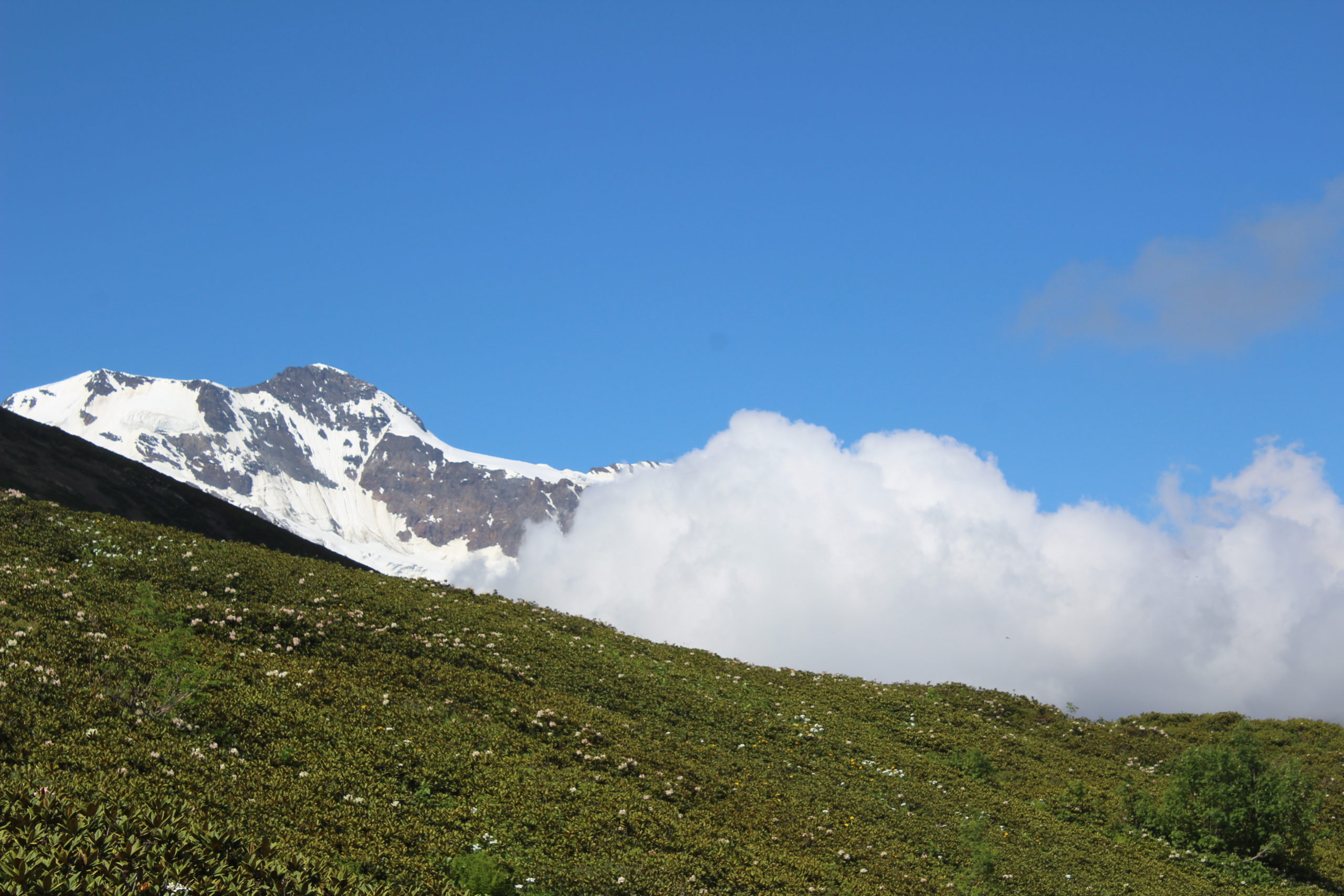
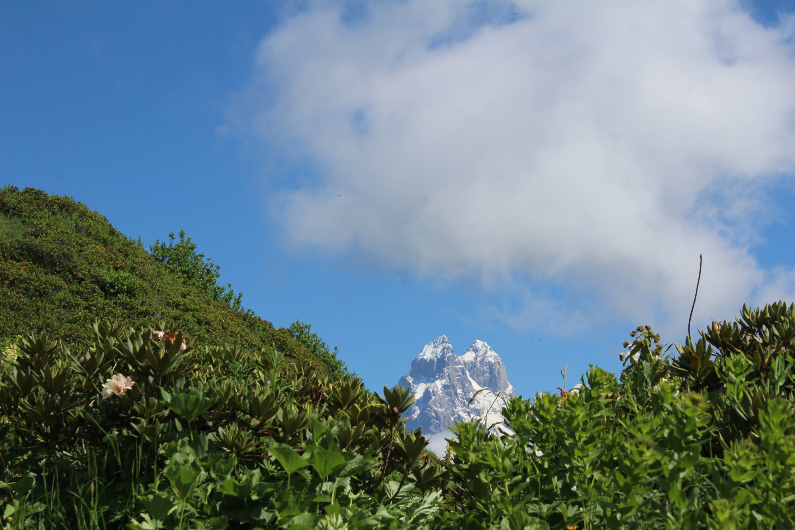
Etseri is a community located in 22 km from the center of Svaneti. On the Google map you cannot find Etseri community as another community of Svaneti, if you search “Etseri” you will find another village in 160km far from Svaneti, but this is not a village which we are talking about. Etseri community includes several villages one of the biggest is Iskari where starts hiking path to Mazeri direction, via Mazeri Mountain. It is very nice path with a great view of Caucasus and Svanetian mountains, e.g. Mt. Ushba 4700m, Glaciers, Svanetian ridge, Enguri Valley and small nice villages. On the Mountain Mazeri (2279m) is situated small church of Archangel and also small lake. lake is so small and not possible to swim there, but it creates nice landscape for photography like a mirror from mountains. On the top of the mountain are great viewpoints and panorama views of Svaneti. The path connects two valleys and two community of Upper Svaneti. The trail finishes in village Mazeri. You will be able to stay in the Guesthouse and have dinner. First part of the path crosses the forests than starts the alpine meadows. In summer season there are lots of mountain flowers, in Autumn lots of blueberry. After the Alpine meadows starts again forests and it continues until village Tvebishi. Mazeri is nearest village from Ushba mountain and village offers you great views of that huge mountain. The highest point is Baki Pass 2460m and lowest point 1440. In Mazeri there are many guesthouses where you can stay, then you are able to continue hiking on the second day to Shdugra waterfalls and Ushba glacier.
Mazeri to Shdugra waterfalls and Ushba glacier hike Distance to waterfall (both way) 10 km to the glacier 15 km;
Difficulty: to waterfall moderate and to the Glacier hard;
Hiking time: 5-6 hour to waterfalls, 7-8 hour to glacier.
Have delicious breakfast in the guesthouse in Mazeri; hosts provide also lunch packets for you, then start hiking to Shdugra waterfalls and Ushba Glacier. Shdugra is the tallest waterfall in Georgia, located in the western part of Mt. Ushba (4700m) first cross the river Dolra; 3-4 km later trip continues through pine tree forest, this part of the path is flat; than cross the river with a wooden bridge and start slope, from the way you can see waterfall and fragments of Mt. Ushba. Second part of the road is more difficult, 1.5 km is slope than reach to the waterfall. After crossing the bridge, you will meet the border policy if you are going to go waterfalls direction; note: they will ask a few questions.
Distance to the waterfall from the village is 5 km and 2-3 hours need one way. From
waterfall to Glacier distance is 2.5 km, but the path is more difficult than the first part, if you have enough experience of hiking, you can reach to the glacier in 1.5-2 hours. In 1 km, you need to cross the river Dolra again. It is the top of the waterfall, views from the top is fantastic; you can see Dolra valley, Svaneti Ridge and mountain Laila (4009m), after the next 1 km you can reach the huge glacier where river Dolra starts. The highest point is 2600 m from sea level, lowest point 1640 m. We don’t recommend continuing hiking to Ushba Glacier direction, because some part of the path is sloppy when it’s wet.
No details found.
No details found.
No details found.


No Details Found
Related Trips
Hike to Mkheri Mountain
There are countless sunset cruises from which you can enjoy the magnificent sunset Santorini is so famous for. Usually beginning in the afternoon, sunset cruisesTour Details
Brilliantly carfted mosque at Abu Dhabi
Sheikh Zayed Grand Mosque is located in Abu Dhabi, the capital city of the United Arab Emirates.[1] The largest mosque in the country, it isTour Details

Lakhushdi to Tsvirmi Day hike
On this day tour, we combine two winter highlights, a glacier walk and a search for the spectacular Aurora Borealis for an amazing day outTour Details
There are no reviews yet.